July 20 CFD

July 20
Falling heights and cooling temperatures aloft over Alberta accompany an approaching upper low across the BC interior during the day Thursday. As the main forcing associated with the upper trough overspreads western Alberta, thunderstorm initiation is likely near the foothills. MLCAPE values may approach 1000-1500J/kg over much of westcentral Alberta, however, thick smoke will likely reduce insolation - especially away from the foothills - which will ultimately determine how much instability builds with daytime heating. H5 flow is near 20 knots, yielding 0-6km shear values near 30 knots. Strong forcing should yield the development of a discontinuous line of thunderstorms comprising the main outer "spiral band" of the upper low, with mainly strong multicells - however, a few brief supercells are likely near the foothills, bringing a risk of severe hail and wind gusts.
Further to the west, a more favourable alignment of shear vectors with the axis of forcing could yield training storms and heavy rainfall amounts. Storms should push into parts of central and northern Alberta into the evening hours.
Elsewhere, a few strong pulse storms are possible in NW Alberta in the afternoon.
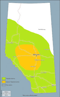


Comments
Post a Comment