July 23 CFD
July 23
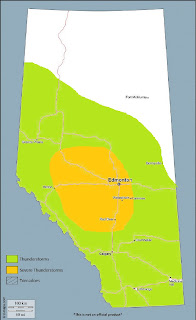
***Severe thunderstorms will be possible across parts of southcentral, central, and eastcentral Alberta on Sunday. A conditional tornado threat may also develop early in the evening over southcentral sections - however, this will be highly dependent on the quality of moisture return into the region***
Discussion:
An upper low off the Alaskan panhandle as of Saturday evening pushes a strong shortwave trough across the BC interior during the day Sunday, which digs south as it rotates through flow aloft. Heights will slowly fall over Alberta as ascent downstream of the trough helps to steepen mid-level lapse rates. As cross-barrier flow strengthens during the day, lee troughing develops along the central and southern foothills – and combined with local terrain circulations, low level moisture should begin to pool into the foothills during the morning.
The manner in which Sunday’s severe thunderstorm potential plays out across central Alberta will depend perhaps in large part on the quality and efficiency of the moisture return cycle during the day. Despite a pocket of low to mid-teen dewpoints in southcentral Alberta Saturday evening, a weak lead wave will translate over the region into Sunday morning, with drying westerly surface flow in its wake. Still, increasing easterly flow during the day should begin to advect moisture from eastcentral Alberta back into the foothills. As the shortwave trough and associated mid-level speed max noses into the central Rockies during the afternoon, strong pressure falls occur in the area of a developing surface low near or just south of Calgary, which should further serve to enhance convergence and subsequent deepening of moisture in a preferred zone north of the low. The amount of instability that develops will depend on the depth of this moisture, but most models agree that MLCAPE values of 1000-1500J/kg are attainable – with locally higher amounts possible. However, if instability remains relatively weak due to a lack of moisture quality, storms will be weaker overall – due also to updraft entrainment issues owing to a CAPE-shear balance strongly weighted to deep layer shear.
Nonetheless, as the H5 speed maximum of 50-55 knots rounding the base of the trough pushes into central Alberta, deep layer shear values will greatly increase – with a large area of 0-6km shear values ranging from 40-70 knots overspreading much of the Edmonton-Calgary corridor by early evening. The timing of the shortwave trough should be such that maximum instability should build up by late afternoon, before erosion of the cap leads to convection initiation near the foothills in the 21-22Z timeframe. Developing storms will then push east during the evening hours, being maintained by upper support and a favourable shear profile – with a few long-lived supercells possible. In an east-west corridor north of the developing surface low, an isallobaric response to strong pressure falls will yield strong, backed surface flow that will help to enhance low level shear – with 0-3km SRH values in excess of 250J/kg possible. This area will also be collocated with the richest low level moisture – and thus, contingent on the quality of low level moisture, could present a conditional tornado threat. Elsewhere across parts of southcentral Alberta, golfball or larger hail and damaging winds, as well as torrential downpours, will be associated threats. The southern extent of the threat area will likely be determined by the position of the surface low - as areas to its south will be in drier, downslope flow. A second round of storms is possible associated with a strong cold front that slashes southeast across the Alberta plain late in the evening and overnight. Momentum from a 60 knot low level jet stream could be transferred to the surface via thunderstorm downdrafts, with some strong to damaging wind gusts possible – especially over eastcentral Alberta by the end of the period.
A few scattered thunderstorms will also be possible across the far north – with strong multicells in the far northeast bringing a marginal severe threat during peak heating.


Comments
Post a Comment