July 13 CFD

July 13
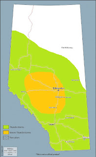
Another well-timed upper disturbance interacts with a moist, unstable boundary layer, especially near a surface trough through northcentral Alberta Thursday afternoon and evening. Combined upper support from the shortwave trough with favourable positioning beneath the left exit region of an H25 jet streak will lead to the development of moderate to strong instability with daytime heating. MLCAPE values of 1000-2000J/kg are common across much of Alberta especially from the Yellowhead north (excluding the far north) – with pockets of up to 3000J/kg possible in near the richer low level moisture in the surface trough. This will result in vigourous deep convection during the afternoon and evening, in an environment of deep layer shear capable of organizing storms into strong multicells and a few supercells. Large hail and damaging winds will be the main threats – with the strongest storms bringing a risk of very large hail.
Activity should more or less progress from west to east following the upper disturbance, with thunderstorm activity gradually waning into the overnight hours. Once again, heavier smoke over western sections may reduce insolation and therefore overall intensity of thunderstorms if locally thick. Further south, on the west side of the surface trough, flow will be generally downslope and therefore relatively dry, with weak to nil convergence along the foothills south of about Rocky Mountain House – and a much warmer day in southern Alberta.
Severe thunderstorms will be possible in the following regions:
- Edson – Whitecourt – Drayton Valley – Edmonton – Rocky Mountain House – Red Deer – Cold Lake – Athabasca – Slave Lake – Lac La Biche


Comments
Post a Comment