July 11 CFD

July 12
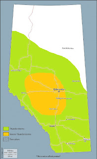
A lee trough helps pool moisture into the central and northern foothills, with MLCAPE values in the 1000-2000J/kg range by late afternoon. The interaction of a subtle shortwave trough with moist, unstable low levels will lead to convection intiation along prominent terrain features in western Alberta. Deep layer shear will be sufficient to organize convection into strong multi-cells and a few supercells, with large hail and damaging winds being the main threats.
Limiting factors include increasing smoke that is advected into the elbow region and north on SW flow aloft, which will reduce insolation and the buildup of instability. However, stronger forcing from the shortwave will help to offset this effect and likely lead to strong thunderstorms in NW Alberta Wed PM.
Mid-level warming and a lack of upper support stifles severe convective development south of about Sundre, with a few very isolated storms possible in that area that will be confined to the foothills. A few generally non-severe storms are possible near Calgary.
The greatest risk for severe storms appears to be in areas including:
Hinton - Edson - Fox Creek - Whitecourt - Drayton Valley - Rocky Mountain House


Comments
Post a Comment