July 6 Convective Discussion

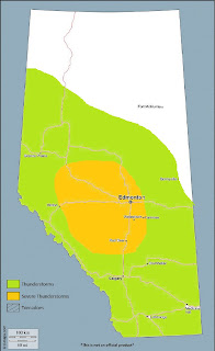
A threat of severe thunderstorms will develop across much of southern and central Alberta on Saturday, with all severe hazards possible.
A 40 knot mid-level jet maximum noses into the Alberta Rockies on Saturday southeast of a slow-moving upper low centered over SW British Columbia, resulting in lee troughing and attendant low level moisture advection that pools into the foothills during the day. Low to mid teen dewpoints can be expected along the foothills, with higher mixing ratios likely with northern extent in the threat area, aided by evapotranspiration of vegetation and the ground surface owing to more abundant recent precipitation across the region compared with areas further south.
In the absence of any major perturbations in flow aloft, convection will likely be initiated by a combination of pooled low level moisture and lift along the terrain, beneath subtly falling mid-level heights during the afternoon. Large scale ascent associated with the exit region of a curved upper-level jet streak, as well as DCVA, will help to steepen mid-level lapse rates, resulting in the development of moderate instability along the foothills, characterized by MLCAPE values of 1500-2000J/kg. Ultimately, the degree of destabilization will be contingent on the intensity of solar heating during the day, necessitating a lack of cloud cover that could otherwise threaten the target area due to its position downstream of prolonged large scale ascent. Nonetheless, the aforementioned large scale ascent will be subtle - and with the orientation of the initiating boundary along the terrain being orthogonal to flow aloft, discrete storm modes will be favoured - with several supercells likely moving off the foothills and toward the Highway 2 corridor by late afternoon.
In general, 0-6km shear values will be modest at 30-35 knots - with values approaching 40 knots where low-level flow is locally backed. This, combined with weak mid and anvil-level storm relative winds, should result in shorter-lived supercells that have a tendency to transition to HP modes after a couple of hours. Hail to the size of golfballs, with severe wind gusts will likely be the main threats - however, low MLLCLs owing to rich boundary layer moisture, as well as appreciable low level CAPE values, could provide some of the conditions necessary for tornadogenesis earlier in the storms' life cycles.
The greatest severe threat appears to be along and just east of the foothills and into the Highway 2 corridor from the Rocky Mountain House area south to the US border, between 3 and 7PM local time.

Comments
Post a Comment