August 13 CFD
August 13
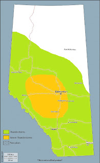
Height falls associated with cooling aloft overspreads much of Alberta on Sunday, as an elongating upper trough of increasing negative tilt digs eastward across BC. Southerly and even southeasterly mid-level flow about the base of the trough will begin to rotate into the province as the upper ridge moves off to the east. The surface pressure field initially responds with deepening lee troughing and the development of a surface low over central sections of the province during the afternoon. Some moisture convergence occurs into the trough and in the vicinity of the developing low, with added terrain effects enhancing pooling along the northern foothills and Swan Hills areas – however, southeasterly flow will not be laden with rich moisture as it originates from drier locales. Therefore, despite progged dewpoints into the low and even mid teens in parts of central Alberta, there is low confidence it will be of any significant depth – due also in part to its brief residence time.
Nonetheless, cooling aloft will steepen mid-level lapse rates atop a moistening boundary layer – and with a period of daytime heating, weak to moderate instability will develop over parts of central Alberta during the afternoon. The only caveat here is that the increasing thrust of mid-level flow over the BC interior will begin to advect the formerly entrenched smoke plume into westcentral sections of the province, which could act to greatly reduce insolation and resultant build up of instability in this area. Still, MLCAPE values are likely to develop into the 1000-1500J/kg range over central Alberta, contributing to the potential of a few strong updrafts across the region by early to mid-afternoon. H5 flow increases from 25-30 knots over the QE2 corridor to 40+ knots in the elbow region – however, with the flow being southerly or southeasterly atop moderate low level flow oriented in a similar direction, 0-6km bulk shear values may not exceed 30 knots in central Alberta. If surface flow can become locally backed to easterly or northeasterly on the northern edge of the low, deep layer shear may here become supportive of updraft rotation, bringing a risk of golfball-sized hail. Steep low-level lapse rates amid deeper, warm and relatively dry boundary layers will also help to increase DCAPE values and contribute to the risk of strong, gusty winds and storms with progressive cold pools – which will reduce overall longevity of any supercells that do develop.
Model guidance suggests a discrete storm or two could develop ahead of the main axis of synoptic forcing, with consistent output from the NAM and SREF revealing a high confidence of a heavier swath of convective precipitation along or just west of the QE2 between YQF and YEG in the 20-22Z timeframe. Some Canadian model solutions favour areas further west – however, less instability here should reduce the overall intensity of storms. Otherwise, strong forcing ahead of the upper trough axis, combined with deep shear vectors being aligned parallel to this axis, will lead to a discontinuous NW to SE arc of thunderstorms that will seed and interact with each other, favouring linear segments of storms pushing northeastwards across the province into the evening – and weakening thereafter.


Comments
Post a Comment