June 13 - Convective Forecast Discussion
 |
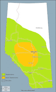
| You don't see any orange because thunderstorms could occur across the entirety of the province on Thursday - save for possibly the extreme SW. |
As of 00Z Wednesday evening, an upper level ridge axis was in place roughly along the 115W parallel over the middle of the province. A strong vort max was noted over northern Haida Gwaii on water vapour imagery, with a weaker lead wave supporting thunderstorms over the central BC interior. Generally slack flow was noted at the surface beneath the ridge, with variable, light winds and dewpoints in the high single digits to low double digits across much of the middle third of the province.
During the overnight period into Thursday morning, elevated thunderstorms will move across central and northern Alberta, supported by approaching mid-level energy from the west, which will aid in breaking down the ridge. These storms will add to in situ low level moisture content, which will go on to support surface-based thunderstorms later in the day. By midday, a 40 knot 500mb jet noses into central Alberta, as a surface low develops in the SE. A weak cold front trailing the low will slide south into southern Alberta and stall during the afternoon, with low level moisture advection occurring behind the front. This moisture, characterized by surface dewpoints locally into the low teens, will begin to pool into the central foothills as low level flow begins turning upslope with daytime heating.
The strongest mid-level forcing for ascent will exist across northern Alberta, which will support numerous thunderstorms during the day - some of which may be strong. Meanwhile, subtle height falls during the day with increasing low level convergence along the central foothills will lead to convection initiation by mid-afternoon. Here, MLCAPE values near 1500J/kg amid 40 knots of 0-6km shear will result in an environment supportive of supercells, with hail up to the size of golf balls possible as storms are still near the foothills. The post-frontal upslope flow pattern will result in messy shear profiles in the lowest levels, reducing the tornado threat.
As these storms move east, and particularly east of the QE2, they will encounter progressively deeper boundary layers, greater DCAPE values, and less favourable storm-relative wind profiles. This will result in progressive outflows with storms growing upscale into one or two bowing segments, with an attendant threat of damaging wind gusts perhaps in excess of 110km/h as storms move southeast into SE Alberta by mid-evening.
Depending on how far south the stalled frontal boundary sets up, severe threat may push south of Calgary, along the wind shift axis and northern side of the moisture gradient.
In eastern Alberta, a supercell threat may develop on the nose of the mid-level jet where moderate CAPE values driven by abundant low-level moisture will support strong updrafts amid favourable deep layer shear. Here, large hail could be possible - but again, unfavourable low level wind fields characterized by veered surface winds will make for less favourable low level shear for tornadoes. Further south, a few strong multicellular structures will be the more likely mode of convection, being away from the axis of greatest shear.
 |
| Here is my target area for tomorrow. Seems pretty classic, with one or two dominant storms developing NW of Calgary and crossing very near to the north side of the city. However, with similar post-frontal upslope setups in the past, the whole play could shift south somewhat. Will monitor obs and satellite trends in the morning. |


Comments
Post a Comment