July 7 CFD

July 7
Strong upper ridge slowly phases east during the period, bringing height falls over NW Alberta, including the elbow region. North Pacific upper low kicks off a potent shortwave trough, which rotates through SW flow aloft over BC and arrives along the continental divide by late in the day. At the surface, hot conditions prevail across the south, with the surface ridge bisecting the province weakening as lee troughing begins to develop along the front range of the Rockies – where a lee low is spawned in the Elbow or extreme NE BC by evening.
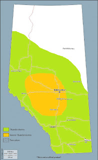
The approaching shortwave trough will help to advect an elevated mixed layer plume out of the US intermountain west into the Alberta elbow by late afternoon, steepening mid-level lapse rates. At the same time, relatively rich low level moisture over central Alberta as of Thursday evening will be advected into the central and northern foothills and into extreme NE BC, pooling into the terrain. The combination of steepening mid-level lapse rates atop a moistening boundary layer and daytime heating will lead to MLCAPE values of 2000-2500J/kg near the foothills south of Grande Prairie. This environment remains capped while awaiting an area of upper divergence associated with DCVA on the nose of the upper trough’s mid-level jet max, and should be released by 00Z. 0-6km bulk shear values also increase to 30-35 knots as the jet max arrives, with a broken line of strong multicells and embedded transient supercells pushing NE off the terrain throughout the evening hours. Hail up to golfball-size and the severe wind gusts will be the main threats in the evening, especially in an area bounded by Dawson Creek, Grande Prairie, and Grande Cache, southwestward toward the foothills and into NE BC. These storms should weaken as they persist over NW Alberta into the overnight hours.
Further south along the foothills, any severe surface-based storms should remain confined to the foothills where low level convergence is maximized, and not much further south than the Robb area. Forcing associated with the ridge-riding shortwave trough will be progressively weaker toward the southeast, however it should help to support a few elevated thunderstorms during the late evening as far south as Calgary, which should push east onto the Alberta plain and weaken into the overnight hours.


Comments
Post a Comment