Posts

July 6 Convective Discussion

Image
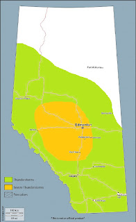
A threat of severe thunderstorms will develop across much of southern and central Alberta on Saturday, with all severe hazards possible. A 40 knot mid-level jet maximum noses into the Alberta Rockies on Saturday southeast of a slow-moving upper low centered over SW British Columbia, resulting in lee troughing and attendant low level moisture advection that pools into the foothills during the day. Low to mid teen dewpoints can be expected along the foothills, with higher mixing ratios likely with northern extent in the threat area, aided by evapotranspiration of vegetation and the ground surface owing to more abundant recent precipitation across the region compared with areas further south.  In the absence of any major perturbations in flow aloft, convection will likely be initiated by a combination of pooled low level moisture and lift along the terrain, beneath subtly falling mid-level heights during the afternoon. Large scale ascent associated with the exit region of a curve

June 13 - Convective Forecast Discussion

Image
You don't see any orange because thunderstorms could occur across the entirety of the province on Thursday - save for possibly the extreme SW.  Widespread thunderstorm activity can be expected across much of Alberta on Thursday as an upper level ridge begins to break down. Areas with moderate instability and ample shear for organized convection will see an increased threat of severe weather, including large hail and damaging winds. As of 00Z Wednesday evening, an upper level ridge axis was in place roughly along the 115W parallel over the middle of the province. A strong vort max was noted over northern Haida Gwaii on water vapour imagery, with a weaker lead wave supporting thunderstorms over the central BC interior. Generally slack flow was noted at the surface beneath the ridge, with variable, light winds and dewpoints in the high single digits to low double digits across much of the middle third of the province.   During the overnight period into Thursday morning

Saturday, June 9 Forecast (Day 3)

Image
A risk of severe thunderstorms will develop across parts of eastern Alberta on Saturday. A significant shortwave trough pivoting about a Gulf of Alaska low will begin to dig into the Pacific Northwest, becoming increasingly negatively tilted over time, with an associated H5 speed max of 60-70 knots nosing into Alberta on Saturday. In response, an elongated, north to south-oriented surface low/trough will develop during the day from central sections into the far south. Low level moisture will be largely scoured out of southern and parts of central Alberta in low level westerly flow during the day on Friday, with the resultant moist axis residing from southcentral Saskatchewan into portions of eastcentral and northeastern Alberta by Saturday morning. As the surface trough begins to deepen during the day, low level moisture return will occur in earnest from Montana and into the warm sector across much of southeast and eastern Alberta. Meanwhile, an increasing southerly comp

May 4 - Convective Forecast Discussion

Image
Scattered thunderstorms are expected to develop over parts of southern Alberta on Friday. Westerly surface flow as of Thursday evening is resulting in a dry air mass over southern Alberta, with dewpoints currently just creeping above the freezing mark as of 01Z in the southwest corner - at a slower rate of return than currently progged. Nonetheless, NWP reveals that a push of Pacific moisture is expected to increase low level moisture in a shallow layer, with surface dewpoints approaching the mid-single digits across much of the southern half of the province by tomorrow afternoon. Weak surface troughing will develop from the SE corner northwestwards toward the northern foothills, resulting in a confluent axis that will help focus moisture and lift along a relatively narrow zone. A plume of moist, mid and upper level westerly flow results in morning cloud atop a standing wave over the southern foothills that overspreads the plains to the east until around midday, after which i

August 13 CFD

Image
August 13 Height falls associated with cooling aloft overspreads much of Alberta on Sunday, as an elongating upper trough of increasing negative tilt digs eastward across BC. Southerly and even southeasterly mid-level flow about the base of the trough will begin to rotate into the province as the upper ridge moves off to the east. The surface pressure field initially responds with deepening lee troughing and the development of a surface low over central sections of the province during the afternoon. Some moisture convergence occurs into the trough and in the vicinity of the developing low, with added terrain effects enhancing pooling along the northern foothills and Swan Hills areas – however, southeasterly flow will not be laden with rich moisture as it originates from drier locales. Therefore, despite progged dewpoints into the low and even mid teens in parts of central Alberta, there is low confidence it will be of any significant depth – due also in part to its brief reside

July 27 CFD

Image
July 27 ***A risk of severe thunderstorms will exist over much of westcentral Alberta on Thursday, with significant severe hail and damaging wind gusts possible in the late afternoon and early evening*** Discussion: Moderate to strong SW flow aloft will exist over the province on Thursday, with subtle height falls ahead of a somewhat weak shortwave trough that passes through during the evening. At the surface, a weak lead wave that tracks over northern Alberta brings a weak cold front to the Elbow that slides southeast and stalls along the central foothills in the afternoon. Further to the south, a lee low develops northwest of Calgary, with hot, dry downslope flow across southern Alberta. As of Wednesday evening, a pool of mid-teen dewpoints exists over parts of westcentral and northcentral Alberta, with the 00Z WSE RAOB revealing somewhat of a skin layer of richer moisture – however, the depth of low level moisture sampled overall isn’t insignificant. The associat