May 4 - Convective Forecast Discussion

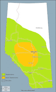
Scattered thunderstorms are expected to develop over parts of southern Alberta on Friday.
Westerly surface flow as of Thursday evening is resulting in a dry air mass over southern Alberta, with dewpoints currently just creeping above the freezing mark as of 01Z in the southwest corner - at a slower rate of return than currently progged. Nonetheless, NWP reveals that a push of Pacific moisture is expected to increase low level moisture in a shallow layer, with surface dewpoints approaching the mid-single digits across much of the southern half of the province by tomorrow afternoon. Weak surface troughing will develop from the SE corner northwestwards toward the northern foothills, resulting in a confluent axis that will help focus moisture and lift along a relatively narrow zone.
A plume of moist, mid and upper level westerly flow results in morning cloud atop a standing wave over the southern foothills that overspreads the plains to the east until around midday, after which it begins clearing out and stronger surface heating follows. Despite subtle height rises and weak upper support in anticyclonic flow aloft, moisture convergence and lift along the confluent axis will be sufficient for convection initiation during the afternoon hours. MLCAPE values of 200-400J/kg will be common in this area, with pockets approaching 500J/kg over parts of the south and southwest - amid 0-6km bulk shear values of 20-30 knots. Relatively dry, well-mixed boundary layers will limit overall buoyancy, as well as increase evaporative cooling potential in the sub-cloud layer - resulting in fairly short-lived, non-severe thunderstorms with progressive cold pools. Still, the stronger storms may be briefly capable of producing small hail and gusty winds.
Thunderstorm chances will be greatest across the far south, and decreasing with northward extent. While convective precipitation is expected along the northern foothills, a general lack of buoyancy will limit updraft strength, such that only a few lightning strikes, if any, will be possible there.

Comments
Post a Comment